Geography
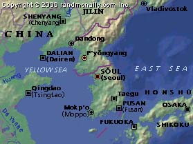
The Korean Peninsula, located in Northeast Asia, is bordered on the north by China and Russia and juts toward Japan to the southeast. The northernmost point is Yup'ojin in Onsong-gun, Hamgyongbuk Province, and the southernmost point is Marado Island, Cheju Province. The westernmost point is Maando Island in Yongch'on-gun, P'yong-anbuk Province, and the easternmost is Dokdo Islets in Ulleung-gun, Gyeongsangbuk Province. Since 1948, the Peninsula has been divided roughly along the 38th parallel with the Republic of Korea to the south and the Democratic People's Republic of Korea to the North; the total land area of the Republic of Korea is 99,394 square kilometers.
The Republic of Korea is composed of nine provinces, with Seoul as the capital city. Other major cities include Pusan, Daegu, Incheon, Gwangju, and Daejeon. The landscape of the country is spectacular in its variations and about 70 percent of it is mountainous, with more than 3000 islands dotting the coastline. There are several major rivers in the South, one of which is the Han River which cuts through Seoul.
Like other countries in the temperate zone, Korea has four distinct seasons. In spring and autumn, the weather is superb: clear, blue skies and warm, gentle sunshine. Summer is relatively hot and humid, with heavy rainfall occurring during the monsoon season. Winter is cold and dry, with occasional snow. However, these cold spells alternate with periods of milder weather.

Article courtesy of the Korean Overseas Information Service.